Image:Location-Pol-Lith-Commonwealth.png
From Wikipedia, the free encyclopedia
Location-Pol-Lith-Commonwealth.png (250 × 115 pixel, file size: 5 KB, MIME type: image/png)
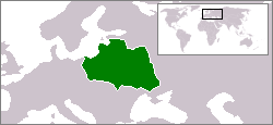
Location map: Polish-Lithuanian Commonwealth (1619).
I made it myself. -- Kpalion 18:35, 23 Apr 2004 (UTC)

I, the creator of this work, hereby release it into the public domain. This applies worldwide.
In case this is not legally possible,
I grant any entity the right to use this work for any purpose, without any conditions, unless such conditions are required by law.
File history
Legend: (cur) = this is the current file, (del) = delete this old version, (rev) = revert to this old version.
Click on date to download the file or see the image uploaded on that date.
- (del) (cur) 23:02, 17 April 2004 . . Kpalion ( Talk | contribs) . . 250×115 (4,824 bytes)
- (del) (rev) 03:54, 17 April 2004 . . Kpalion ( Talk | contribs) . . 250×115 (4,829 bytes) ({{msg:GFDL}})
-
Edit this file using an external application
See the setup instructions for more information.
File links
Categories: User-created public domain images | Maps of the Polish-Lithuanian Commonwealth | Maps of the history of Poland | Maps of the history of Lithuania