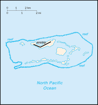
Image:Palmyra Atoll-CIA WFB Map.png
From Wikipedia, the free encyclopedia
- Image
- File history
- File links
No higher resolution available.
Palmyra_Atoll-CIA_WFB_Map.png (330 × 355 pixel, file size: 5 KB, MIME type: image/png)
|
|
This is a file from the Wikimedia Commons. The description on its description page there is shown below. |
|
|
Summary
Español: Mapa del Atolón Palmyra
- Subject: Palmyra Atoll map
- Source: CIA World Factbook
 |
This image is in the public domain because it contains materials that originally came from the United States Central Intelligence Agency's World Factbook. |
 |
|
English | Français | +/- |
||
 A vector version of this image ("SVG") is available. For more information about vector graphics, read about Commons transition to SVG. English | Français | Polski | +/- |
 |
File links
No pages on the English Wikipedia link to this file. (Pages on other projects are not counted.)
Category: Maps of Palmyra Atoll