Image:Map of USA FL.svg
From Wikipedia, the free encyclopedia
- Image
- File history
- File links
No higher resolution available.
Map_of_USA_FL.svg (286 × 186 pixel, file size: 167 KB, MIME type: image/svg+xml)
|
|
This is a file from the Wikimedia Commons. The description on its description page there is shown below. |
|
|
| Description |
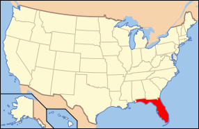
Map of USA with Florida highlighted |
|---|---|
| Source |
{{{Source}}} |
| Date |
{{{Date}}} |
| Author |
{{{Author}}} |
| Permission |
see below |
| Other versions | image:Map of USA with state names.svg |
 |
Permission is granted to copy, distribute and/or modify this document under the terms of the GNU Free Documentation License, Version 1.2 or any later version published by the Free Software Foundation; with no Invariant Sections, no Front-Cover Texts, and no Back-Cover Texts. Subject to disclaimers. |
|
|
This file is licensed under Creative Commons Attribution 2.0 License |
|
|
This file is licensed under Creative Commons Attribution ShareAlike 1.0 License |
|
|
This file is licensed under Creative Commons Attribution ShareAlike 2.0 License. In short: you are free to share and make derivative works of the file under the conditions that you appropriately attribute it, and that you distribute it only under a license identical to this one. |
File links
The following pages on the English Wikipedia link to this file (pages on other projects are not listed):
- Florida
- Putnam County, Florida
- Clay County, Florida
- Marion County, Florida
- Alachua County, Florida
- Baker County, Florida
- Bay County, Florida
- Bradford County, Florida
- Brevard County, Florida
- Broward County, Florida
- Calhoun County, Florida
- Charlotte County, Florida
- Citrus County, Florida
- Collier County, Florida
- Columbia County, Florida
- Miami-Dade County, Florida
- DeSoto County, Florida
- Dixie County, Florida
- Duval County, Florida
- Escambia County, Florida
- Flagler County, Florida
- Franklin County, Florida
- Gadsden County, Florida
- Gilchrist County, Florida
- Glades County, Florida
- Gulf County, Florida
- Hamilton County, Florida
- Hardee County, Florida
- Hendry County, Florida
- Hernando County, Florida
- Highlands County, Florida
- Hillsborough County, Florida
- Holmes County, Florida
- Indian River County, Florida
- Jackson County, Florida
- Lafayette County, Florida
- Jefferson County, Florida
- Lake County, Florida
- Lee County, Florida
- Leon County, Florida
- Levy County, Florida
- Liberty County, Florida
- Madison County, Florida
- Manatee County, Florida
- Nassau County, Florida
- Martin County, Florida
- Monroe County, Florida
- Okaloosa County, Florida
- Okeechobee County, Florida
- Orange County, Florida
- Osceola County, Florida
- Palm Beach County, Florida
- Pasco County, Florida
- Pinellas County, Florida
- Polk County, Florida
- St. Johns County, Florida
- St. Lucie County, Florida
- Santa Rosa County, Florida
- Sarasota County, Florida
- Seminole County, Florida
- Sumter County, Florida
- Suwannee County, Florida
- Taylor County, Florida
- Union County, Florida
- Volusia County, Florida
- Wakulla County, Florida
- Walton County, Florida
- Washington County, Florida
- User:Karlhahn
- User:Seav/Locator maps