Image:The Catlins.jpg
From Wikipedia, the free encyclopedia
- Image
- File history
- File links
The_Catlins.jpg (392 × 309 pixel, file size: 26 KB, MIME type: image/jpeg)
|
|
This is a file from the Wikimedia Commons. The description on its description page there is shown below. |
|
|
Summary
| Description |
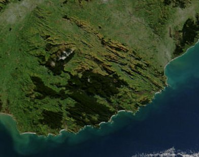
This satellite image shows the Catlins, a region in the southeast of New Zealand's South Island, after a severe blizzard hit the island in July 2003. The dark green areas are forested, while most of the light green and yellow areas are farmed. White patches are covered in snow. |
|||
|---|---|---|---|---|
| Source |
NASA's Earth Observatory |
|||
| Date |
2002-10-23 |
|||
| Author |
Jacques Descloitres, MODIS Rapid Response Team at NASA GSFC |
|||
| Permission |
|
|||
| Other versions | Full view of the South Island at Image:South Island blizzard 2003.jpg |

This satellite image shows the Catlins, a region in the southeast of New Zealand's South Island.
Image courtesy Jacques Descloitres, MODIS Rapid Response Team at NASA GSFC.
SOURCE: http://earthobservatory.nasa.gov/NaturalHazards/shownh.php3?img_id=10797
”The purpose of NASA's Earth Observatory is to provide a freely-accessible publication on the Internet where the public can obtain new satellite imagery and scientific information about our home planet. The focus is on Earth's climate and environmental change. In particular, we hope our site is useful to public media and educators. Any and all materials published on the Earth Observatory are freely available for re-publication or re-use, except where copyright is indicated. We ask that NASA's Earth Observatory be given credit for its original materials.”
File links