Image:Satellite image of Adelaide South Australia.jpg
From Wikipedia, the free encyclopedia
Satellite_image_of_Adelaide_South_Australia.jpg (136 × 340 pixel, file size: 18 KB, MIME type: image/jpeg)
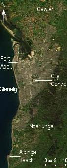
Satellite image of Adelaide South Australia, including the outer areas still considered part of larger Adelaide. Taken from a 4400x5800 250m per pixel image of South Australia. Referred to street directory, road atlas and my own knowledge of the street layout from Taxi Driving to ensure the arrows' accuracy.
 |
This file is in the public domain because it was created by NASA. NASA copyright policy states that "NASA material is not protected by copyright unless noted". ( NASA copyright policy page or JPL Image Use Policy). Warnings:
|
|
File history
Legend: (cur) = this is the current file, (del) = delete this old version, (rev) = revert to this old version.
Click on date to download the file or see the image uploaded on that date.
- (del) (cur) 17:38, 23 October 2004 . . Diceman ( Talk | contribs) . . 136×340 (18,030 bytes)
- (del) (rev) 11:08, 13 October 2004 . . Diceman ( Talk | contribs) . . 136×340 (17,543 bytes) (Satellite image of Adelaide South Australia, including the outer areas still considered part of the larger Adelaide. Taken from a hi-res shot of most of South Australia. Referred to street, directory, road atlas and my own knowledge of the street layout f)
- (del) (rev) 11:06, 13 October 2004 . . Diceman ( Talk | contribs) . . 136×340 (17,543 bytes)
- (del) (rev) 09:53, 13 October 2004 . . Diceman ( Talk | contribs) . . 136×340 (17,160 bytes) (Satellite image of Adelaide South Australia, including the outer areas still considered part of Adelaide proper. Taken from a hi-res shot of South Australia. Referred to street, directory, road atlas and my own knowledge of the street layout from Taxi Dri)
-
Edit this file using an external application
See the setup instructions for more information.
File links
- Adelaide
- Gawler, South Australia
- Glenelg, South Australia
- Port Adelaide
- Le Fevre Peninsula
Metadata
This file contains additional information, probably added from the digital camera or scanner used to create or digitize it. If the file has been modified from its original state, some details may not fully reflect the modified image.
| Orientation | Normal |
|---|---|
| Software used | ACD Systems Digital Imaging |
| File change date and time | 02:57, 24 October 2004 |
| Y and C positioning | 1 |
| Exif version | 2.2 |
| DateTime subseconds | 222 |
Category: NASA images