Image:Timezones optimized.png
From Wikipedia, the free encyclopedia
- Image
- File history
- File links

Size of this preview: 800 × 331 pixel
Image in higher resolution (4779 × 1979 pixel, file size: 1.34 MB, MIME type: image/png)
|
|
This is a file from the Wikimedia Commons. The description on its description page there is shown below. |
|
|
Summary
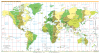
Original Source: CIA World Factbook
Modified by: User:Chochopk adding DST start/end information (originally Image:Timezones Better.gif)
Modified by: User:Jamadagni by reducing the size of the GIF file by one-third by converting it to PNG. Added UN-recognized dispute borders to India/Pakistan and India
This file was created for 2005. As of 2006, it is already out of date. Known discrepancy includes (but not limited to) Indiana U.S.A, West Australia, and Sri Lanka. See en:Time in Indiana and en:Time in Australia.
Licensing
 |
This image is in the public domain because it contains materials that originally came from the United States Central Intelligence Agency's World Factbook. |
 |
Format
Two SVG versions of a more up-to-date version of this image are available here and here
  It is recommended that the other file be used. If you just added this tag and want to nominate this image for deletion, please check if it is used and if so replace it with the new image.
Afterwards please add the following code to here: (Please review the discussion here.)
Important: Before deleting this file, check if the new one is really superior! Also check:
Afrikaans | Alemannisch | العربية | Български | Česky | Dansk | Deutsch | English | Ελληνικά | Esperanto | Español | Français | Galego | עברית | हिन्दी | Magyar | Bahasa Indonesia | Ido | Italiano | 日本語 | 한국어 | Nederlands | Norsk (nynorsk) | Polski | Português | Românǎ | Русский | Slovenščina | Српски | Svenska | Türkçe | 简体中文 | 正體中文 | +/- |
 |
This Map image should be recreated using vector graphics as an SVG file. This has several advantages; see Commons:Images for cleanup for more information. If an SVG form of this image is already available, please upload it. After uploading an SVG, replace this template with template {{ SupersededSVG|new image name.svg}} in this image. |
|
Català | Česky | Dansk | Deutsch | English | Esperanto | Español | Français | Italiano | 日本語 | 한국어 | Nederlands | Polski | Português | Русский | العربية | 正體中文 | +/- |
|
File links
- Time zone
- List of time zones
- User talk:Neuromancien
- Time in Pakistan
- User talk:Nightstallion/β
- Wikipedia:Picture peer review/Timezones
- Wikipedia:WikiProject Current Local City Time
Category: Time zones